A remarkable tropospheric ducting occurred on August 11 and 12, 2020 between Poland, Sweden and Denmark. The propagation forecasts, which use color hue to scale their intensity, featured red shades over the Baltic Sea. Such a propagation strength is very rare, if ever seen on a forecast for this area. I was looking forward for something extraordinary, especially on the microwave bands. My stationary Wi-Fi DXing setup has been damaged three months ago. I could not miss such an opening, so a DX-pedition was the only option. In the evening of August 11 I made an opportunistic decision to visit the Dylewska Góra in north-eastern Poland. A few hours later, I was standing there with an antenna inside a lookout tower.
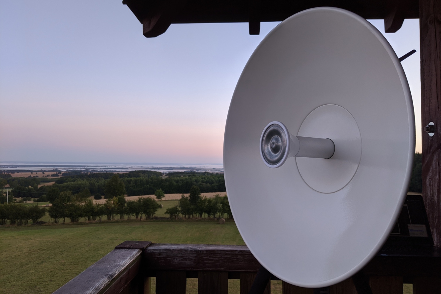
With its tip at 312 m ASL, Dylewska Góra (Dylewska Mountain) near Ostróda is the highest hill of the whole north-eastern Poland. There is a wooden lookout tower atop which provides fantastic unobstructed views between 175° to 340° azimuth with optical visibility up to around 50 km. The driving distance from my location is 135 km and I arrived there in two hours, in the middle of the night (2 AM). I knew that place as I have visited it already once with my friend. Back then in the 2018 we encountered a typical morning inversion without any notable long-range ducting (see the report: Early morning on Dylewska Góra).
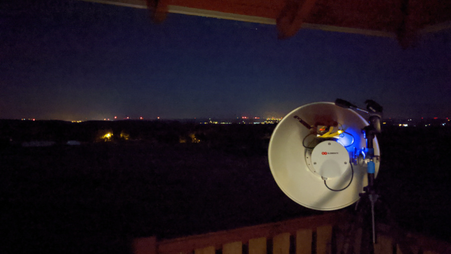
I took the following equipment for 5 GHz Wi-Fi DXing:
- UltraDish TP 550 parabolic dish antenna (27.5 dBi) with MikroTik RB912UAG board and R11e-5HnD miniPCIe radio.
- Raspberry PI dedicated for Wi-Fi scanning with MTscan software (read more: 5 GHz Wardriving).
- Tripod, laptop and a USB powerbank.
I quickly installed the antenna, which is a medium size (55 cm) dual-polarization dish. Taking that into account I was just hoping for Bornholm (Danish island in the Baltic Sea) and maybe farther Danish or Swedish coast. The tropospheric ducting was still in a development phase at night, but I easily logged some networks up to 180-250 km at the very beginning.
Before the sunrise I noticed the first tentative log from outside Poland. The network’s name ystmast-lt03 seems to be pointing to Ystad town in Sweden. I was not able to identify it via Wigle.net database, because it uses a proprietary protocol that does not broadcast typical 802.11 beacon frames. Furthermore, the word “mast”, the same as in English, is different than Polish “maszt”. I received it together with Frednowy village, which is almost the same direction (around 4° of azimuth difference).
The distance to Ystad from Dylewska Góra is at least 445 km. This network uses MikroTik hardware with 2×2 MIMO radio, configured in TDMA (nv2) mode on a 5220 MHz VHT80 channel. Signal level up to -86 dBm.
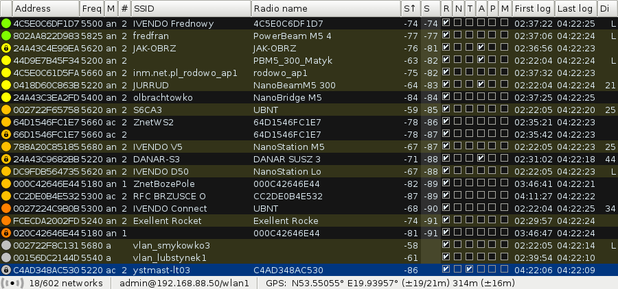
At the sunrise I finally logged the long-awaited Bornholm, which was successfully identified via Wigle.net database. The network’s name Aakirkeby-3 also contains the town’s name. Nice signal level peak, up to -82 dBm at a distance of around 367 km. It uses Ubiquiti hardware with 2×2 MIMO radio, configured in airMAX mode on a 5500 MHz HT40+ channel.
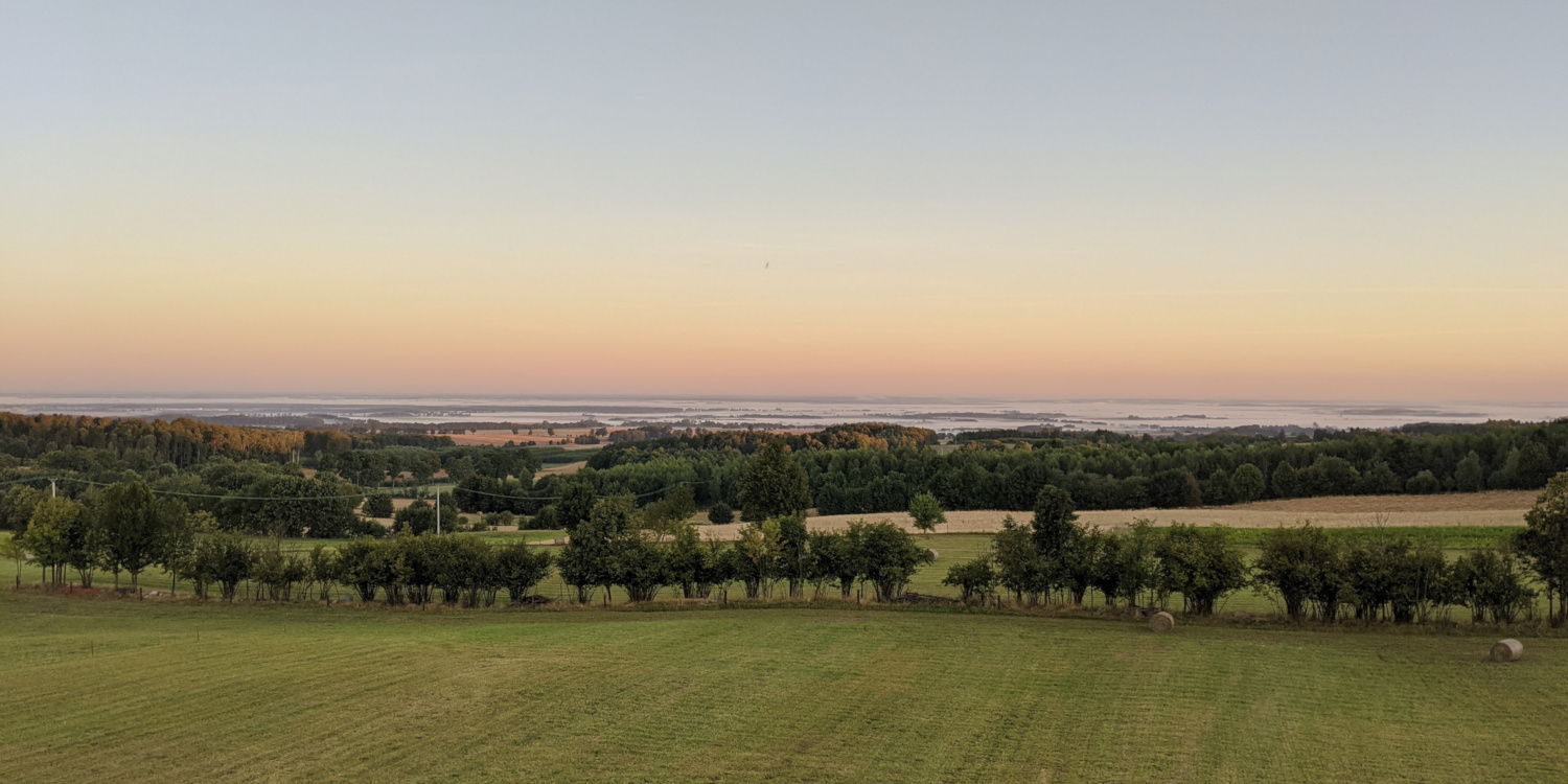
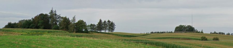
The morning sun revealed a breathtaking display with a deep orange horizon. That area is famous for its lakes, but this wasn’t them, just some fogs in the distance.
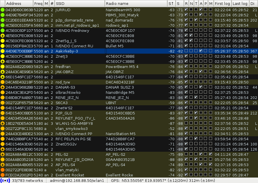
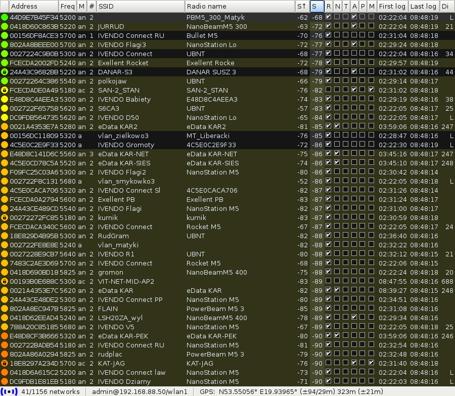
The morning also featured an unexpected scenario. I logged several networks from south-western Poland at distances of over 400 km, including Świeradów-Zdrój, Szklarska Poręba and Żary. Those ducting paths were not included in the forecast at all. I thought that Denmark will not return, but it didn’t keep me out from trying.
The propagation peak occurred around 6:30 UTC (8:30 LT) when I logged another Danish network named wified_16-3 at a signal level of -90 dBm. This network uses Ubiquiti hardware with 2×2 MIMO radio, configured in airMAX AC PTMP Mixed Mode on a 5240 MHz HT20 channel.
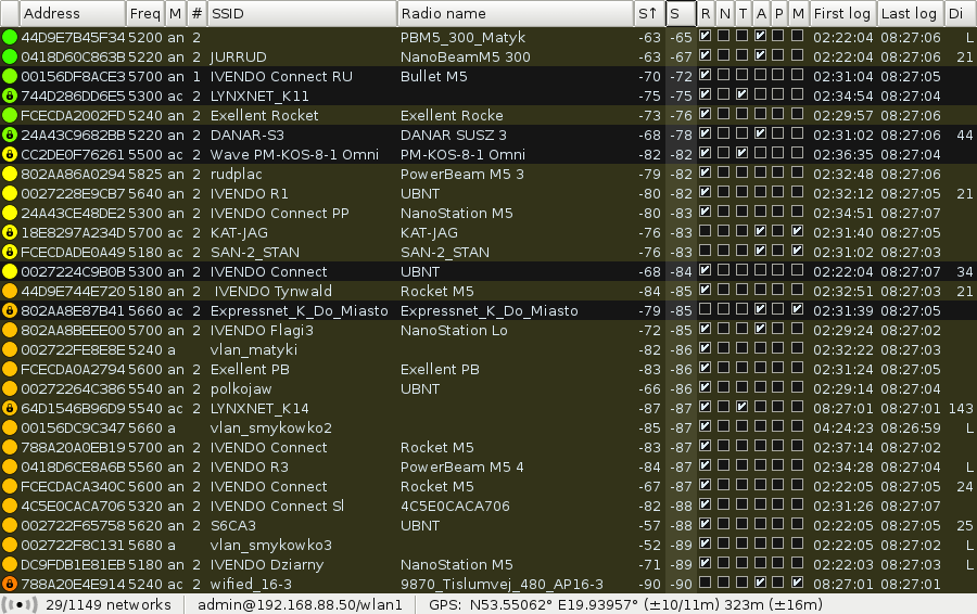
The device name included a postal code of Sindal (9870) in Northern Jutland, Nordjylland, and more importantly, the exact address Tislumvej 480. I double checked the distance, because I could not believe it… 745 km!! My previous record from Ukraine (460+ km) was instantly beaten by almost 300 km. The following terrain profile was generated using RadioMobile software without taking the Earth’s curvature into consideration for tropospheric ducting propagation.

I did some research about that place and I found a mast at nearby address Tislumvej 490 (not 480). There is a FM broadcast transmitter of Radio Sindal on 104.1 MHz listed as 0.3 kW ERP on FMLIST. The following view is available on Google Street View. I also found a nice close-up at westergaardbolig.dk and some 5 GHz antennas are visible there. Nothing interesting was found for the Tislumvej 480 query though.
About 20 minutes later I logged another network VIT-NET-MID-AP2 from Denmark, identified immediately via Wigle.net database as Middelfart, but “just” at 688 km. It uses LigoWave hardware with 2×2 MIMO radio, configured on a 5300 MHz VHT20 frequency. Signal level up to -83 dBm.
The long-range tropospheric ducting propagation faded away at 7 UTC and I left the Dylewska Góra after 7 hours of continuous Wi-Fi DXing. I logged 4 networks via transbaltic paths.
The table below contains the farthest identified networks (⩾ 350 km) received on August 12, 2020.
| BSSID | Freq | SSID (Radio name) | S↑ | UTC | Approximate location [km] | |
| 1. Transbaltic paths | ||||||
788A20E4E914 |
5240 | wified_16-3 (9870_Tislumvej_480_AP16-3) |
-90 | 06:27 | DNK Sindal | 745 |
00193B0E688C |
5300 | VIT-NET-MID-AP2 |
-83 | 06:47 ÷ 06:48 | DNK Middelfart | 688 |
C4AD348AC530 |
5220 | ystmast-lt03 (C4AD348AC530) |
-86 | 02:22 ÷ 06:33 | S Ystad (tentative) | 445 |
44D9E7D0EBBF |
5500 | Aakirkeby-3 |
-82 | 03:26 ÷ 05:04 | DNK Aakirkeby | 367 |
| 2. Land-line paths | ||||||
44D9E70CB979 |
5640 | G (G) |
-88 | 04:35 | POL Świeradów-Zdrój | 432 |
44D9E70E1FFD |
5260 | J (Rocket M5) |
-85 | 04:35 ÷ 04:37 | POL Świeradów-Zdrój | 427 |
00272270C633 |
5220 | bestnet1-szw-airmax.pl-717170530 |
-89 | 06:06 ÷ 06:31 | POL Szklarska Poręba | 427 |
002722BAD268 |
5220 | bestnet1-sa-airmax.pl-717170530 |
-90 | 06:07 | POL Kostrzyca | 414 |
0418D6CEAFAD |
5280 | Feel-HD1 (Rocket 5AC Prism) |
-90 | 05:37 | POL Żary | 387 |
F09FC28A3E6B |
5200 | Feel-LC (aclite LC) |
-86 | 05:17 ÷ 05:39 | POL Żary | 387 |
In total, I logged 1156 Wi-Fi 5 GHz networks. The full log is available there: https://wifi.fmdx.pl/logs/dylewska2020
Only 50% of them were successfully identified and can be seen in the following map.
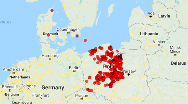
Map of received and identified networks (click for a full interactive version)
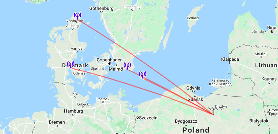
The following map shows the tropospheric propagation forecast with an overlay of my best paths.

Atmospheric soundings from Łeba, Poland (exactly at the ducting path to Denmark) at the Baltic Sea coast performed on August 12 at 00 and 12 UTC reveal inversions layers.
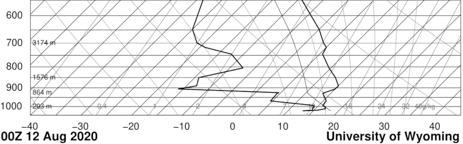
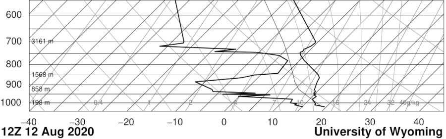
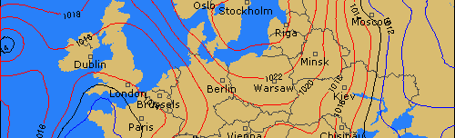
As usually, the best ducting conditions occurred along the lines of equal pressure level (between 1022 and 1024 hPa MSLP).
As I mentioned, my stationary mast with antenna for 5 GHz Wi-Fi DXing is still awaiting a rebuild. Until then, I think I will take another trip if the conditions favor and Dylewska Góra is always a great choice. Nevertheless, I think such an overwhelming DX record of almost 750 km 5 GHz Wi-Fi reception will be extremely difficult to beat, if it ever will be.
Congratulations Konrad, quite amazing!